
Open User Map
Open User Map is the essential WordPress plugin for building an interactive, user-driven map with frontend submissions, approval workflows, and no.
Visit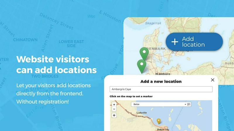
About Open User Map
Open User Map is an essential interactive maps plugin for WordPress that empowers website owners to create collaborative, user-driven maps without any coding knowledge or complex setup requirements. This powerful tool eliminates the need for a Google Maps API key, making it accessible to anyone who wants to build a community map where visitors can contribute locations, routes, and areas directly from the frontend. At its core, Open User Map solves the critical problem of maintaining an up-to-date, comprehensive map by distributing the responsibility of data collection to your audience. Website owners, community managers, directory operators, event organizers, and local business advocates all need this plugin to streamline their mapping needs. The plugin offers a robust approval workflow system that ensures all user submissions are reviewed before going live, maintaining quality control while encouraging participation. With over 15,000 active installs, a perfect 100% five-star rating, and recognition as the number two map plugin on WordPress.org, Open User Map has proven itself as a reliable, must-have solution. The platform provides extensive customization options including custom fields, marker categories with unique icons, and the ability to add lines and areas for trails, zones, and regions. For those requiring advanced functionality, the PRO version unlocks even more powerful features like custom image maps, advanced filter interfaces, upvoting systems, star ratings, and opening hours display. Whether you are building a community resource directory, a tourist attraction guide, an event venue map, or a neighborhood information hub, Open User Map provides the necessary infrastructure to create an engaging, interactive mapping experience that grows with your community contributions.
Features of Open User Map
Frontend Location Submissions with Approval Workflow
This critical feature allows website visitors to add and edit locations directly on your map without needing backend access. When a user clicks the "Add location" button, they can place a marker and submit detailed information through customizable forms. Every submission enters a moderation queue where you can review, approve, or reject it before it becomes visible to the public. This approval workflow is absolutely necessary for maintaining data quality and preventing spam or inappropriate content. Additionally, users can edit their existing submitted locations, ensuring your map always reflects the most current and accurate information from your community.
Effortless Categorization and Filtering of Markers
Organizing your map markers into distinct categories with unique icons is a must-have capability for any serious map implementation. This feature enables you to group locations logically, making complex maps instantly understandable at a glance. Visitors can filter markers by category to find exactly what they need without visual clutter. The flexibility extends further by allowing each location to belong to multiple categories simultaneously, ensuring all relevant attributes are represented. This hierarchical organization system transforms a simple collection of points into a structured, searchable database that users can navigate intuitively and efficiently.
Lines and Areas for Routes, Zones, and Regions
Going beyond simple point markers, this essential feature lets you add routes, paths, zones, and regions directly to your map. Whether you need to highlight hiking trails, service areas, event grounds, neighborhoods, construction zones, or any custom shape, Lines and Areas provides the necessary tools. Distances and area sizes are calculated automatically, so routes and polygons include helpful measurements right out of the box. This capability is indispensable for tourism websites showing walking paths, real estate sites displaying property boundaries, or event organizers mapping festival grounds with specific zones.
Custom Fields for Tailored Data Collection
Enhancing your map with flexible custom fields is a priority feature that allows you to gather exactly the information you need from map interactions. You can add text boxes, links, checkboxes, and dropdown menus to suit your specific requirements. This customization capability ensures your data collection is comprehensive and user-specific, whether you need business hours, contact information, website URLs, or category selections. The ability to define what information users provide makes Open User Map adaptable for any industry, from restaurant directories to historical landmark guides, ensuring you capture all necessary details for your particular use case.
Use Cases of Open User Map
Community Resource Directory for Local Services
Local community websites absolutely need Open User Map to create a comprehensive directory of essential services like healthcare providers, grocery stores, pharmacies, and public facilities. Residents can submit new locations they discover, update information for existing services, and add details such as hours of operation, contact information, and service categories. The approval workflow ensures only verified, accurate information appears on the map, maintaining trust within the community. This living directory becomes an indispensable resource that grows organically as more people contribute, reducing the administrative burden on website owners while providing immense value to visitors seeking local information.
Tourist Attraction and Points of Interest Guide
Tourism websites must implement Open User Map to build an interactive guide featuring attractions, restaurants, hotels, and landmarks that visitors can explore and contribute to. Tourists can add hidden gems they discover, share tips about local favorites, and update information about current conditions or seasonal availability. The categorization feature allows filtering by attraction type, price range, or distance, making trip planning effortless. With the Lines and Areas feature, you can highlight walking tours, scenic drives, or district boundaries, creating a complete travel companion that evolves with every visitor contribution.
Event Venue and Festival Ground Mapping
Event organizers require Open User Map to create detailed maps of festival grounds, conference venues, or large event spaces. Attendees can locate stages, food vendors, restrooms, first aid stations, and parking areas with precision. The custom image map feature is particularly valuable here, allowing you to upload an event layout or floor plan and place interactive markers directly on it. Users can add their own vendor booths or meetup points, and the approval system keeps everything organized. This interactive approach dramatically improves attendee experience by eliminating confusion and reducing the number of directional questions staff must handle.
Neighborhood and Community Information Hub
Homeowners associations, neighborhood watch groups, and community organizations need Open User Map to create a centralized information hub for their area. Residents can mark important locations like parks, community centers, public art installations, walking trails, and safety zones. The upvoting and star rating features allow the community to highlight the best playgrounds, most popular walking routes, or highest-rated local businesses. Regions functionality enables you to define neighborhood boundaries, districts, or custom areas of interest, making it easy for new residents to learn about their surroundings and for long-time residents to share their local knowledge.
Frequently Asked Questions
Do I need coding skills or a Google Maps API key to use Open User Map?
No, absolutely not. Open User Map is designed specifically to eliminate these barriers. You need zero coding knowledge to install, configure, and manage the plugin. Furthermore, it does not require a Google Maps API key, which saves you from the complexity of setting up API credentials and worrying about usage limits or billing charges. The plugin handles all mapping functionality out of the box with a simple installation and activation process, making it accessible for complete beginners and experienced website owners alike.
How does the approval workflow for user submissions work?
When a visitor submits a location through the frontend, it goes directly into a moderation queue that only you can access. You have full control to review each submission, check the details provided, and decide whether to approve or reject it. Approved locations become immediately visible on your map, while rejected submissions are removed from the queue. This workflow is absolutely essential for maintaining data quality, preventing spam, and ensuring only accurate and appropriate content appears on your map. You can also edit submitted information before approval if minor corrections are needed.
Can I customize the appearance and data fields of my map?
Yes, Open User Map offers extensive customization options that are necessary for tailoring the map to your specific needs. You can add custom fields such as text boxes, links, checkboxes, and dropdown menus to collect exactly the information you require. Marker categories allow you to organize locations with unique icons for instant visual recognition. For advanced users, the PRO version adds custom image maps, advanced filter interfaces, and the ability to display opening hours with a live "Open Now" indicator. These customization features ensure your map matches your brand and functional requirements perfectly.
Is there a free version available, and what does the PRO trial include?
Yes, there is a fully functional free version available for download on WordPress.org that includes core features like frontend submissions, approval workflows, marker categories, and custom fields. For users who need advanced functionality, Open User Map offers a 7-day free PRO trial with no credit card required and no automatic conversion to a paid subscription at the end. The PRO trial unlocks all premium features including custom image maps, advanced filter interfaces, upvoting and star rating systems, opening hours display, and regions functionality. This trial gives you complete access to evaluate whether the PRO features are necessary for your project before making any commitment.
Pricing of Open User Map
Open User Map offers a free version available on WordPress.org that includes essential features for creating user-contributed maps with approval workflows. For users requiring advanced functionality, there is a PRO version available for purchase. Specific pricing details for the PRO version are available on the Open User Map website, and a 7-day free trial allows you to test all PRO features without any financial commitment.
Similar to Open User Map

Built2WinWeb AI Strength Scanner
Custom PHP websites, AI Indexing Pack ($599 one‑time), and WebAgentScan SaaS ($9/mo). MCP, A2A, llms.txt, full ownership.

Webleadr
Webleadr instantly finds and contacts businesses without websites, delivering essential web design leads in just a few clicks.

Idearium
Idearium creates impactful websites and digital strategies that drive growth and elevate your brand's online presence.

FilexHost
Easily host and share files in seconds with drag-and-drop uploads and instant shareable links.

Crawlkit
CrawlKit is the essential API for effortlessly scraping and structuring data from any website or platform in one call.

Best Boilerplates
Launch your SaaS app faster with top boilerplates that offer essential features and flexible pricing options.

Shadcn UI Kit
Accelerate your web projects with Shadcn UI Kit's ready-to-use dashboards, templates, and components designed for React.

Clio Websites
Clio Websites builds custom, high-converting sites with SEO to grow your business.